- Subscribe to RSS Feed
- Mark as New
- Mark as Read
- Bookmark
- Subscribe
- Printer Friendly Page
- Report Inappropriate Content
04-30-2007
08:13 AM
This is the final installment in Captain Ray Stark's springtime trip report. To view the first day, click here, and for the previous day, click here. (To enlarge photos, click on the picture.)
Day 3: Five Legs To Phoenix (Louisville to St. Louis to Tulsa to Las Vegas to San Diego to Phoenix)
By the time we arrive at the airport in Louisville (SDF), it is just getting light.
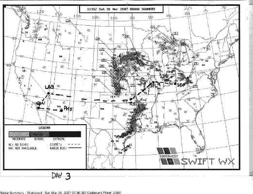
Before leaving my hotel room, I spent time looking at the moving weather display on the Weather Channel. Two days ago I was concerned about today's leg through Tulsa (TUL). The weather depiction indicates the line has broken, and TUL appears to be in the clear! After that, weather is no longer an issue. Our radar summary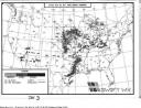 is below:
Louisville to St. Louis: The flight to St. Louis (STL) is a quick one with light chop. The weather we dealt with yesterday has rotated slowly north and west, as if pushed by a huge hand. STL is still under cloudy skies and it is raining lightly but this presents no problem for our arrival. En route, I notice the winds down low are exactly 90 degrees to the 95 knot jet stream winds aloft. More possibility of tornados.
We get into STL early, and I have time to wander over and chat with an old Air Force buddy who is a SWA Captain. I heard his distinctive voice inbound to STL. Funny thing about this airline life: I last saw Bruce walking through the terminal about three years ago, and we chatted for a couple of minutes. We are such a big Company now that you can go for years and not see someone, even in your own base.
St. Louis to Tulsa: The leg to TUL goes about as painlessly as the previous one. We taxi out to the end of the runway, check the radar, and blast off toward TUL. We climb painfully slowly because of crossing traffic, avoidance vectors by Air Traffic Control (ATC) for traffic conflicts a few miles down range, congested airspace, and just plain busy controllers. While Scott is flying, I am running the radios, talking to ATC, checking the weather in TUL, doing performance data for our landing in TUL, and trying to beg a shortcut out of ATC, once clear of traffic. By the time I get my chores done and have a moment to stretch, Scott has us leveled off at 34,000 feet (aka Flight Level 340 or FL340).
Throughout the flight we experience light chop and have kept all passengers seated. From our vantage point
is below:
Louisville to St. Louis: The flight to St. Louis (STL) is a quick one with light chop. The weather we dealt with yesterday has rotated slowly north and west, as if pushed by a huge hand. STL is still under cloudy skies and it is raining lightly but this presents no problem for our arrival. En route, I notice the winds down low are exactly 90 degrees to the 95 knot jet stream winds aloft. More possibility of tornados.
We get into STL early, and I have time to wander over and chat with an old Air Force buddy who is a SWA Captain. I heard his distinctive voice inbound to STL. Funny thing about this airline life: I last saw Bruce walking through the terminal about three years ago, and we chatted for a couple of minutes. We are such a big Company now that you can go for years and not see someone, even in your own base.
St. Louis to Tulsa: The leg to TUL goes about as painlessly as the previous one. We taxi out to the end of the runway, check the radar, and blast off toward TUL. We climb painfully slowly because of crossing traffic, avoidance vectors by Air Traffic Control (ATC) for traffic conflicts a few miles down range, congested airspace, and just plain busy controllers. While Scott is flying, I am running the radios, talking to ATC, checking the weather in TUL, doing performance data for our landing in TUL, and trying to beg a shortcut out of ATC, once clear of traffic. By the time I get my chores done and have a moment to stretch, Scott has us leveled off at 34,000 feet (aka Flight Level 340 or FL340).
Throughout the flight we experience light chop and have kept all passengers seated. From our vantage point 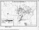 we can see both chunks of the weather system displayed on the map (above) and feel lucky to have such a wide passage to get through en route to Tulsa.
About 80 miles out, ATC advises us of an area of heavy precipitation right in front of us. We see it, but it is well below our altitude. Another example of the limitations of the ground based radar ATC uses. It doesn't see weather very well. Thank God for airborne weather radar. We get some moderate chop as we pass, and put the Flight Attendants down yet again. The jet stream winds passing 20,000 feet are almost 100 knots, which is a lot for this low altitude. Yet another indication tornados are still a possibility in this area, should that weather down south move up this way. The arrival into TUL is far more rapid than the climb out of STL, and we soon find ourselves on final to Runway 18L.
We push five minutes late in TUL. The actual flight planned flight time is less than scheduled so we should arrive in LAS a few minutes early.
After another minor bout of chop and wave action over the Front Range of the Rockies, we are back into smooth air and enjoy the ride as we pass the Grand Canyon just north of Flagstaff, AZ. The picture below
we can see both chunks of the weather system displayed on the map (above) and feel lucky to have such a wide passage to get through en route to Tulsa.
About 80 miles out, ATC advises us of an area of heavy precipitation right in front of us. We see it, but it is well below our altitude. Another example of the limitations of the ground based radar ATC uses. It doesn't see weather very well. Thank God for airborne weather radar. We get some moderate chop as we pass, and put the Flight Attendants down yet again. The jet stream winds passing 20,000 feet are almost 100 knots, which is a lot for this low altitude. Yet another indication tornados are still a possibility in this area, should that weather down south move up this way. The arrival into TUL is far more rapid than the climb out of STL, and we soon find ourselves on final to Runway 18L.
We push five minutes late in TUL. The actual flight planned flight time is less than scheduled so we should arrive in LAS a few minutes early.
After another minor bout of chop and wave action over the Front Range of the Rockies, we are back into smooth air and enjoy the ride as we pass the Grand Canyon just north of Flagstaff, AZ. The picture below 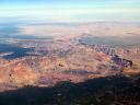 shows the view to the north, and you can see the Colorado River cutting its way down into the canyon (upper right) as it passes out of Glen Canyon Dam at the southwestern edge of Lake Powell.
The next picture
shows the view to the north, and you can see the Colorado River cutting its way down into the canyon (upper right) as it passes out of Glen Canyon Dam at the southwestern edge of Lake Powell.
The next picture is but a part of the rest of the canyon, looking northwest. You can see Grand Canyon Airport on the lower left and see the Lodge at the south rim lookout at the edge of the canyon. Too much scenery to gather into even two pictures.
As we make our arrival into sunny LAS, the approach controllers change our runway to 19L. This means we will fly adjacent to the Strip on approach to the airport.
As we cross the western edge of lake Mead about 25 miles west of LAS, we see the lakeside view of Hoover dam.
is but a part of the rest of the canyon, looking northwest. You can see Grand Canyon Airport on the lower left and see the Lodge at the south rim lookout at the edge of the canyon. Too much scenery to gather into even two pictures.
As we make our arrival into sunny LAS, the approach controllers change our runway to 19L. This means we will fly adjacent to the Strip on approach to the airport.
As we cross the western edge of lake Mead about 25 miles west of LAS, we see the lakeside view of Hoover dam. 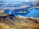 Behind the dam are the towers marking the location of the dam bypass bridge currently under construction. Note the white "tub ring" around the far lake edge. Lake Mead is down some 90 feet from its normal high and currently reportedly holds only 70 percent of capacity. This is a visual measure of the decade-long drought affecting the Southwest. Just out of the picture to the right is one of the main boat ramps into Lake Mead. The lake shore has retreated there nearly three-fourths of a mile since the drought began.
A minute or so later, we are crossing yet another boat ramp
Behind the dam are the towers marking the location of the dam bypass bridge currently under construction. Note the white "tub ring" around the far lake edge. Lake Mead is down some 90 feet from its normal high and currently reportedly holds only 70 percent of capacity. This is a visual measure of the decade-long drought affecting the Southwest. Just out of the picture to the right is one of the main boat ramps into Lake Mead. The lake shore has retreated there nearly three-fourths of a mile since the drought began.
A minute or so later, we are crossing yet another boat ramp  and marina now high and dry.
Now on Approach ATC frequency, and with the Stratosphere Tower
and marina now high and dry.
Now on Approach ATC frequency, and with the Stratosphere Tower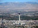 in sight, we are cleared for the visual approach to 19L. We can easily see this tower from across town and proceed directly toward it before turning left to land.
Then a left turn to the runway...
As I turn final to land, off to our right after the Stratosphere is the Strip.
in sight, we are cleared for the visual approach to 19L. We can easily see this tower from across town and proceed directly toward it before turning left to land.
Then a left turn to the runway...
As I turn final to land, off to our right after the Stratosphere is the Strip. 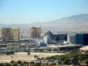 Hard to believe this place was a spot in the road back in the '40s.
We land and head to our gate about ten minutes early. At this point in the day we are scheduled for an airplane swap with an hour and a half "airport appreciation" time before taking another plane to San Diego (SAN) and then home to Phoenix (PHX). Both Scott and I have dinner plans with our wives, so light snacking is on order for our wait in LAS.
LAS-SAN: Having flown three legs in a -700, we now pile into a -300 and make our nests yet again. Scott is once again driving, and we take off to SAN and enjoy a nice smooth and relaxing leg to San Diego. Just south of LAS, we pass over a dry lakebed
Hard to believe this place was a spot in the road back in the '40s.
We land and head to our gate about ten minutes early. At this point in the day we are scheduled for an airplane swap with an hour and a half "airport appreciation" time before taking another plane to San Diego (SAN) and then home to Phoenix (PHX). Both Scott and I have dinner plans with our wives, so light snacking is on order for our wait in LAS.
LAS-SAN: Having flown three legs in a -700, we now pile into a -300 and make our nests yet again. Scott is once again driving, and we take off to SAN and enjoy a nice smooth and relaxing leg to San Diego. Just south of LAS, we pass over a dry lakebed 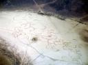 where someone has been busy cutting major high-speed cookies on the lake floor. One rain and they will be all gone.
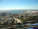 As we arrive into SAN, we are greeted by a beautiful spring Saturday. The bay is full of sailboats, and the view is incredible.
A better view in closer as Scott flies a perfect approach. As usual.
We land in SAN and pull into the gate knowing we have only one more leg to go. The Operations Agent who meets us informs us we are involved in a no-notice aircraft swap, so we get to fold up our tent and move to yet another plane. However, this new plane is running about 15 minutes late. We drag our bags to another jetbridge and wait with the passengers in the boarding area. When our plane arrives, we are greeted by the same two Pilots who brought us our plane in LAS.
The delay has been caused by a failed Standby Artificial Horizon (ADI). The LAS Maintenance personnel have no spare ADI in stock for the 737-700, so the only way to get it fixed expeditiously is to get it to PHX where they have a spare ADI. Otherwise, the plane must be taken out of service awaiting a part to be flown in. This would mean lengthy passenger delays and possibly cancellations.
The Federal Aviation Administration-approved Minimum Equipment List (MEL) allows for certain equipment to be inoperative and still maintain the aircraft as airworthy. The MEL says you can fly the plane as long as you don't fly above any cloud layers. (The Standby ADI allows you to fly through weather if the two main ADIs fail.) Today, our Standby ADI will be the big blue sky, as there is not a cloud in sight between SAN and PHX.
As we arrive into SAN, we are greeted by a beautiful spring Saturday. The bay is full of sailboats, and the view is incredible.
A better view in closer as Scott flies a perfect approach. As usual.
We land in SAN and pull into the gate knowing we have only one more leg to go. The Operations Agent who meets us informs us we are involved in a no-notice aircraft swap, so we get to fold up our tent and move to yet another plane. However, this new plane is running about 15 minutes late. We drag our bags to another jetbridge and wait with the passengers in the boarding area. When our plane arrives, we are greeted by the same two Pilots who brought us our plane in LAS.
The delay has been caused by a failed Standby Artificial Horizon (ADI). The LAS Maintenance personnel have no spare ADI in stock for the 737-700, so the only way to get it fixed expeditiously is to get it to PHX where they have a spare ADI. Otherwise, the plane must be taken out of service awaiting a part to be flown in. This would mean lengthy passenger delays and possibly cancellations.
The Federal Aviation Administration-approved Minimum Equipment List (MEL) allows for certain equipment to be inoperative and still maintain the aircraft as airworthy. The MEL says you can fly the plane as long as you don't fly above any cloud layers. (The Standby ADI allows you to fly through weather if the two main ADIs fail.) Today, our Standby ADI will be the big blue sky, as there is not a cloud in sight between SAN and PHX.  The same cannot be said for the rest of the country.
As we turn over the Pacific heading south and then east to PHX, we are greeted with a stunning view of the lower San Diego Bay. Another reason why no other job has a better view
The same cannot be said for the rest of the country.
As we turn over the Pacific heading south and then east to PHX, we are greeted with a stunning view of the lower San Diego Bay. Another reason why no other job has a better view 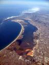 than this one.
We land in PHX about 60 hours after our initial departure. We have flown approximately 5,500 miles through an unfolding weather picture causing havoc across the Midwest. In eleven legs, we have been airborne over 18 hours. We have flown three real approaches in weather and each time, sighted the airport prior to 1,000 feet above the ground. In all the turbulence and wave action, rain and atmospheric tumult, no Crew Member or passenger has been injured. No metal has been bent, and we actually saved gas and time over what was scheduled. We have flown over 850 of Southwest's Customers to their destinations safely and as smoothly as possible. And in a week, barely a thought of this week will remain in my brain because this week was absolutely routine and typical of what domestic Flight Crews face in their weekly flying schedules. Southwest launches over 3,200 flights a day and most resemble one of these flights Scott and I flew this week.
If you were a little bored reading all these details, that is partly the intent of this story. Many people have worked hard since the Wright brother's first flight to make flying through the air a routine and safe operation. If reading this made you a little tired, that is understandable. Many of the trips flown by SWA Crews are four days long. Now you know why we really appreciate having a few days off to recharge before the next trip. Traveling takes its toll on you. We Crew Members get somewhat used to traveling but nothing is like home.
Dorothy was so right about that.
than this one.
We land in PHX about 60 hours after our initial departure. We have flown approximately 5,500 miles through an unfolding weather picture causing havoc across the Midwest. In eleven legs, we have been airborne over 18 hours. We have flown three real approaches in weather and each time, sighted the airport prior to 1,000 feet above the ground. In all the turbulence and wave action, rain and atmospheric tumult, no Crew Member or passenger has been injured. No metal has been bent, and we actually saved gas and time over what was scheduled. We have flown over 850 of Southwest's Customers to their destinations safely and as smoothly as possible. And in a week, barely a thought of this week will remain in my brain because this week was absolutely routine and typical of what domestic Flight Crews face in their weekly flying schedules. Southwest launches over 3,200 flights a day and most resemble one of these flights Scott and I flew this week.
If you were a little bored reading all these details, that is partly the intent of this story. Many people have worked hard since the Wright brother's first flight to make flying through the air a routine and safe operation. If reading this made you a little tired, that is understandable. Many of the trips flown by SWA Crews are four days long. Now you know why we really appreciate having a few days off to recharge before the next trip. Traveling takes its toll on you. We Crew Members get somewhat used to traveling but nothing is like home.
Dorothy was so right about that.
 is below:
Louisville to St. Louis: The flight to St. Louis (STL) is a quick one with light chop. The weather we dealt with yesterday has rotated slowly north and west, as if pushed by a huge hand. STL is still under cloudy skies and it is raining lightly but this presents no problem for our arrival. En route, I notice the winds down low are exactly 90 degrees to the 95 knot jet stream winds aloft. More possibility of tornados.
We get into STL early, and I have time to wander over and chat with an old Air Force buddy who is a SWA Captain. I heard his distinctive voice inbound to STL. Funny thing about this airline life: I last saw Bruce walking through the terminal about three years ago, and we chatted for a couple of minutes. We are such a big Company now that you can go for years and not see someone, even in your own base.
St. Louis to Tulsa: The leg to TUL goes about as painlessly as the previous one. We taxi out to the end of the runway, check the radar, and blast off toward TUL. We climb painfully slowly because of crossing traffic, avoidance vectors by Air Traffic Control (ATC) for traffic conflicts a few miles down range, congested airspace, and just plain busy controllers. While Scott is flying, I am running the radios, talking to ATC, checking the weather in TUL, doing performance data for our landing in TUL, and trying to beg a shortcut out of ATC, once clear of traffic. By the time I get my chores done and have a moment to stretch, Scott has us leveled off at 34,000 feet (aka Flight Level 340 or FL340).
Throughout the flight we experience light chop and have kept all passengers seated. From our vantage point
is below:
Louisville to St. Louis: The flight to St. Louis (STL) is a quick one with light chop. The weather we dealt with yesterday has rotated slowly north and west, as if pushed by a huge hand. STL is still under cloudy skies and it is raining lightly but this presents no problem for our arrival. En route, I notice the winds down low are exactly 90 degrees to the 95 knot jet stream winds aloft. More possibility of tornados.
We get into STL early, and I have time to wander over and chat with an old Air Force buddy who is a SWA Captain. I heard his distinctive voice inbound to STL. Funny thing about this airline life: I last saw Bruce walking through the terminal about three years ago, and we chatted for a couple of minutes. We are such a big Company now that you can go for years and not see someone, even in your own base.
St. Louis to Tulsa: The leg to TUL goes about as painlessly as the previous one. We taxi out to the end of the runway, check the radar, and blast off toward TUL. We climb painfully slowly because of crossing traffic, avoidance vectors by Air Traffic Control (ATC) for traffic conflicts a few miles down range, congested airspace, and just plain busy controllers. While Scott is flying, I am running the radios, talking to ATC, checking the weather in TUL, doing performance data for our landing in TUL, and trying to beg a shortcut out of ATC, once clear of traffic. By the time I get my chores done and have a moment to stretch, Scott has us leveled off at 34,000 feet (aka Flight Level 340 or FL340).
Throughout the flight we experience light chop and have kept all passengers seated. From our vantage point 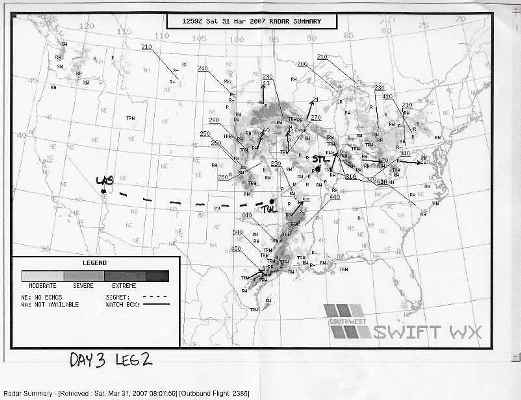 we can see both chunks of the weather system displayed on the map (above) and feel lucky to have such a wide passage to get through en route to Tulsa.
About 80 miles out, ATC advises us of an area of heavy precipitation right in front of us. We see it, but it is well below our altitude. Another example of the limitations of the ground based radar ATC uses. It doesn't see weather very well. Thank God for airborne weather radar. We get some moderate chop as we pass, and put the Flight Attendants down yet again. The jet stream winds passing 20,000 feet are almost 100 knots, which is a lot for this low altitude. Yet another indication tornados are still a possibility in this area, should that weather down south move up this way. The arrival into TUL is far more rapid than the climb out of STL, and we soon find ourselves on final to Runway 18L.
We push five minutes late in TUL. The actual flight planned flight time is less than scheduled so we should arrive in LAS a few minutes early.
After another minor bout of chop and wave action over the Front Range of the Rockies, we are back into smooth air and enjoy the ride as we pass the Grand Canyon just north of Flagstaff, AZ. The picture below
we can see both chunks of the weather system displayed on the map (above) and feel lucky to have such a wide passage to get through en route to Tulsa.
About 80 miles out, ATC advises us of an area of heavy precipitation right in front of us. We see it, but it is well below our altitude. Another example of the limitations of the ground based radar ATC uses. It doesn't see weather very well. Thank God for airborne weather radar. We get some moderate chop as we pass, and put the Flight Attendants down yet again. The jet stream winds passing 20,000 feet are almost 100 knots, which is a lot for this low altitude. Yet another indication tornados are still a possibility in this area, should that weather down south move up this way. The arrival into TUL is far more rapid than the climb out of STL, and we soon find ourselves on final to Runway 18L.
We push five minutes late in TUL. The actual flight planned flight time is less than scheduled so we should arrive in LAS a few minutes early.
After another minor bout of chop and wave action over the Front Range of the Rockies, we are back into smooth air and enjoy the ride as we pass the Grand Canyon just north of Flagstaff, AZ. The picture below 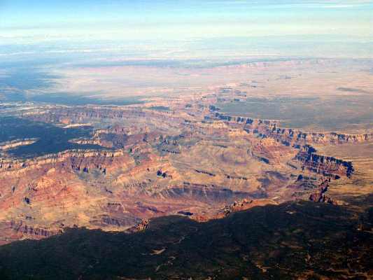 shows the view to the north, and you can see the Colorado River cutting its way down into the canyon (upper right) as it passes out of Glen Canyon Dam at the southwestern edge of Lake Powell.
The next picture
shows the view to the north, and you can see the Colorado River cutting its way down into the canyon (upper right) as it passes out of Glen Canyon Dam at the southwestern edge of Lake Powell.
The next picture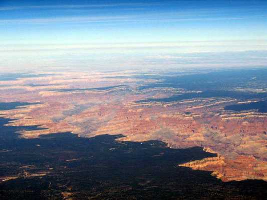 is but a part of the rest of the canyon, looking northwest. You can see Grand Canyon Airport on the lower left and see the Lodge at the south rim lookout at the edge of the canyon. Too much scenery to gather into even two pictures.
As we make our arrival into sunny LAS, the approach controllers change our runway to 19L. This means we will fly adjacent to the Strip on approach to the airport.
As we cross the western edge of lake Mead about 25 miles west of LAS, we see the lakeside view of Hoover dam.
is but a part of the rest of the canyon, looking northwest. You can see Grand Canyon Airport on the lower left and see the Lodge at the south rim lookout at the edge of the canyon. Too much scenery to gather into even two pictures.
As we make our arrival into sunny LAS, the approach controllers change our runway to 19L. This means we will fly adjacent to the Strip on approach to the airport.
As we cross the western edge of lake Mead about 25 miles west of LAS, we see the lakeside view of Hoover dam.  Behind the dam are the towers marking the location of the dam bypass bridge currently under construction. Note the white "tub ring" around the far lake edge. Lake Mead is down some 90 feet from its normal high and currently reportedly holds only 70 percent of capacity. This is a visual measure of the decade-long drought affecting the Southwest. Just out of the picture to the right is one of the main boat ramps into Lake Mead. The lake shore has retreated there nearly three-fourths of a mile since the drought began.
A minute or so later, we are crossing yet another boat ramp
Behind the dam are the towers marking the location of the dam bypass bridge currently under construction. Note the white "tub ring" around the far lake edge. Lake Mead is down some 90 feet from its normal high and currently reportedly holds only 70 percent of capacity. This is a visual measure of the decade-long drought affecting the Southwest. Just out of the picture to the right is one of the main boat ramps into Lake Mead. The lake shore has retreated there nearly three-fourths of a mile since the drought began.
A minute or so later, we are crossing yet another boat ramp 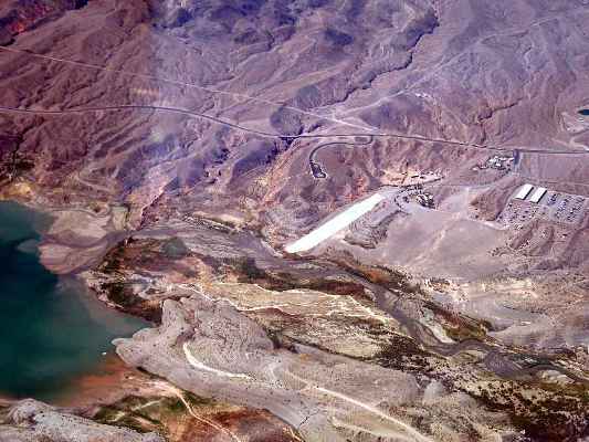 and marina now high and dry.
Now on Approach ATC frequency, and with the Stratosphere Tower
and marina now high and dry.
Now on Approach ATC frequency, and with the Stratosphere Tower in sight, we are cleared for the visual approach to 19L. We can easily see this tower from across town and proceed directly toward it before turning left to land.
Then a left turn to the runway...
As I turn final to land, off to our right after the Stratosphere is the Strip.
in sight, we are cleared for the visual approach to 19L. We can easily see this tower from across town and proceed directly toward it before turning left to land.
Then a left turn to the runway...
As I turn final to land, off to our right after the Stratosphere is the Strip. 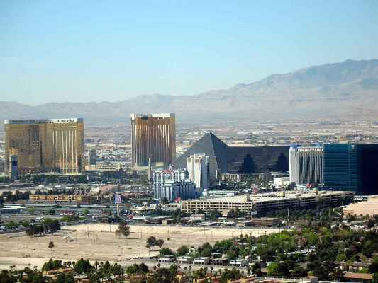 Hard to believe this place was a spot in the road back in the '40s.
We land and head to our gate about ten minutes early. At this point in the day we are scheduled for an airplane swap with an hour and a half "airport appreciation" time before taking another plane to San Diego (SAN) and then home to Phoenix (PHX). Both Scott and I have dinner plans with our wives, so light snacking is on order for our wait in LAS.
LAS-SAN: Having flown three legs in a -700, we now pile into a -300 and make our nests yet again. Scott is once again driving, and we take off to SAN and enjoy a nice smooth and relaxing leg to San Diego. Just south of LAS, we pass over a dry lakebed
Hard to believe this place was a spot in the road back in the '40s.
We land and head to our gate about ten minutes early. At this point in the day we are scheduled for an airplane swap with an hour and a half "airport appreciation" time before taking another plane to San Diego (SAN) and then home to Phoenix (PHX). Both Scott and I have dinner plans with our wives, so light snacking is on order for our wait in LAS.
LAS-SAN: Having flown three legs in a -700, we now pile into a -300 and make our nests yet again. Scott is once again driving, and we take off to SAN and enjoy a nice smooth and relaxing leg to San Diego. Just south of LAS, we pass over a dry lakebed  where someone has been busy cutting major high-speed cookies on the lake floor. One rain and they will be all gone.
 As we arrive into SAN, we are greeted by a beautiful spring Saturday. The bay is full of sailboats, and the view is incredible.
A better view in closer as Scott flies a perfect approach. As usual.
We land in SAN and pull into the gate knowing we have only one more leg to go. The Operations Agent who meets us informs us we are involved in a no-notice aircraft swap, so we get to fold up our tent and move to yet another plane. However, this new plane is running about 15 minutes late. We drag our bags to another jetbridge and wait with the passengers in the boarding area. When our plane arrives, we are greeted by the same two Pilots who brought us our plane in LAS.
The delay has been caused by a failed Standby Artificial Horizon (ADI). The LAS Maintenance personnel have no spare ADI in stock for the 737-700, so the only way to get it fixed expeditiously is to get it to PHX where they have a spare ADI. Otherwise, the plane must be taken out of service awaiting a part to be flown in. This would mean lengthy passenger delays and possibly cancellations.
The Federal Aviation Administration-approved Minimum Equipment List (MEL) allows for certain equipment to be inoperative and still maintain the aircraft as airworthy. The MEL says you can fly the plane as long as you don't fly above any cloud layers. (The Standby ADI allows you to fly through weather if the two main ADIs fail.) Today, our Standby ADI will be the big blue sky, as there is not a cloud in sight between SAN and PHX.
As we arrive into SAN, we are greeted by a beautiful spring Saturday. The bay is full of sailboats, and the view is incredible.
A better view in closer as Scott flies a perfect approach. As usual.
We land in SAN and pull into the gate knowing we have only one more leg to go. The Operations Agent who meets us informs us we are involved in a no-notice aircraft swap, so we get to fold up our tent and move to yet another plane. However, this new plane is running about 15 minutes late. We drag our bags to another jetbridge and wait with the passengers in the boarding area. When our plane arrives, we are greeted by the same two Pilots who brought us our plane in LAS.
The delay has been caused by a failed Standby Artificial Horizon (ADI). The LAS Maintenance personnel have no spare ADI in stock for the 737-700, so the only way to get it fixed expeditiously is to get it to PHX where they have a spare ADI. Otherwise, the plane must be taken out of service awaiting a part to be flown in. This would mean lengthy passenger delays and possibly cancellations.
The Federal Aviation Administration-approved Minimum Equipment List (MEL) allows for certain equipment to be inoperative and still maintain the aircraft as airworthy. The MEL says you can fly the plane as long as you don't fly above any cloud layers. (The Standby ADI allows you to fly through weather if the two main ADIs fail.) Today, our Standby ADI will be the big blue sky, as there is not a cloud in sight between SAN and PHX.  The same cannot be said for the rest of the country.
As we turn over the Pacific heading south and then east to PHX, we are greeted with a stunning view of the lower San Diego Bay. Another reason why no other job has a better view
The same cannot be said for the rest of the country.
As we turn over the Pacific heading south and then east to PHX, we are greeted with a stunning view of the lower San Diego Bay. Another reason why no other job has a better view  than this one.
We land in PHX about 60 hours after our initial departure. We have flown approximately 5,500 miles through an unfolding weather picture causing havoc across the Midwest. In eleven legs, we have been airborne over 18 hours. We have flown three real approaches in weather and each time, sighted the airport prior to 1,000 feet above the ground. In all the turbulence and wave action, rain and atmospheric tumult, no Crew Member or passenger has been injured. No metal has been bent, and we actually saved gas and time over what was scheduled. We have flown over 850 of Southwest's Customers to their destinations safely and as smoothly as possible. And in a week, barely a thought of this week will remain in my brain because this week was absolutely routine and typical of what domestic Flight Crews face in their weekly flying schedules. Southwest launches over 3,200 flights a day and most resemble one of these flights Scott and I flew this week.
If you were a little bored reading all these details, that is partly the intent of this story. Many people have worked hard since the Wright brother's first flight to make flying through the air a routine and safe operation. If reading this made you a little tired, that is understandable. Many of the trips flown by SWA Crews are four days long. Now you know why we really appreciate having a few days off to recharge before the next trip. Traveling takes its toll on you. We Crew Members get somewhat used to traveling but nothing is like home.
Dorothy was so right about that.
than this one.
We land in PHX about 60 hours after our initial departure. We have flown approximately 5,500 miles through an unfolding weather picture causing havoc across the Midwest. In eleven legs, we have been airborne over 18 hours. We have flown three real approaches in weather and each time, sighted the airport prior to 1,000 feet above the ground. In all the turbulence and wave action, rain and atmospheric tumult, no Crew Member or passenger has been injured. No metal has been bent, and we actually saved gas and time over what was scheduled. We have flown over 850 of Southwest's Customers to their destinations safely and as smoothly as possible. And in a week, barely a thought of this week will remain in my brain because this week was absolutely routine and typical of what domestic Flight Crews face in their weekly flying schedules. Southwest launches over 3,200 flights a day and most resemble one of these flights Scott and I flew this week.
If you were a little bored reading all these details, that is partly the intent of this story. Many people have worked hard since the Wright brother's first flight to make flying through the air a routine and safe operation. If reading this made you a little tired, that is understandable. Many of the trips flown by SWA Crews are four days long. Now you know why we really appreciate having a few days off to recharge before the next trip. Traveling takes its toll on you. We Crew Members get somewhat used to traveling but nothing is like home.
Dorothy was so right about that.
22 Comments
You must be a registered user to add a comment. If you've already registered, sign in. Otherwise, register and sign in.